Main Streets of Arbury: Carlton Way - Part 3

                      
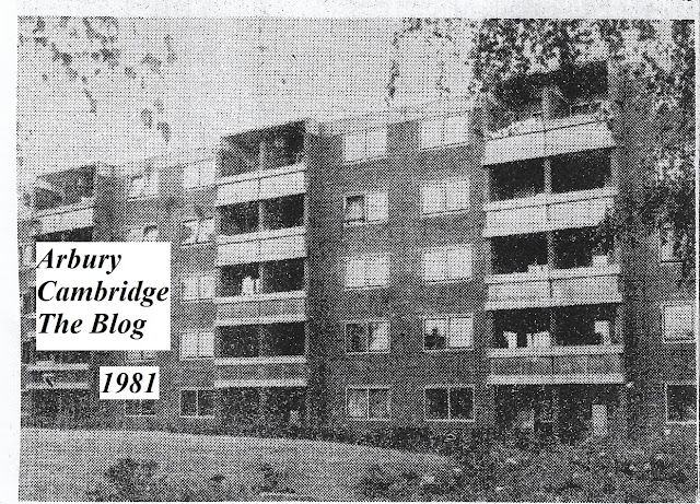
Photograph from Sara Payne's 1981 'Down Your Street' article - the Kingsway Flats. The photograph was taken by the 'Hump' and the seats on the corner of Verulam Way. The seats were let into the low wall, facing the hills and the flats. They were removed sometime around the late 1990s/early 21st century.

The South Arbury 'Hump'... North Arbury had the Arbury Adventure Playground in Wagstaff Close, the Arbury Town Park and the Arbury Community Centre in Campkin Road. South Arbury couldn't really compete with those. But the children of the South did have the Hump, the seats, the Kingsway hills and the Kingsway blocks to play on, as well as St Alban's and Arbury Court rec. The hump is fondly remembered for being an exciting bike ride - and for being an excellent place to kick up dust - fascinating play for many children back in the '60s, '70s and '80s.

The Hump was bricked in circa 2008. Some of us still miss it.

Continuing our look at Sara Payne's 1981 Down Your Street article from the Cambridge Weekly News, and our delvings into our own memory banks and the transcripts of the Arbury 1980 project. 

Hall Farm and Manor Farm became North and South Arbury. Note that most of King's Hedges Road did not exist until the late 1970s, when it was redirected and extended across North Arbury, lopping off the original end of Arbury Road by Arbury Camp Farm.

Sara Payne spoke to Mr Whitehead, of Tedder Way, who was 'rather an authority on Arbury...'

When Mr Whitehead first came to Arbury in the fifties it was 'a sea of mud in a large, bleak landscape.' There is still something of that bleakness about the approaches to the Kingsway Flats. The flats themselves are quite snug inside with decent sized sitting rooms (residents were bunked up in front of Wimbledon when I was round there last week) but it is the draughty passageways where the wind gets up that are the bone of contention, together with the sign posting of the flats. It is very hard to track down the flats at the back.

Elderly residents confessed to finding it lonely. 'It can be lonely up here,' said Miss Ethel Stubbings, who used to work as a domestic help in the now demolished nurses' home which stood in Queen Anne Terrace. She would have been used to more bustle there.

While the health authority hold a variety of clinics on the ground floor of the Kingsway Flats, there seems to be a great need for a day room for the residents, somewhere where they could meet, have social evenings, play games and find companionship.

'Cambridge Weekly News', 1981.

Since those days, the Kingsway has lost the block of garages near Carlton Way. Does anybody remember the tennis courts on top, with their wire enclosures? If we remember rightly, there were two, side by side, and the metal supports looked rusty even back in the early 1970s. We never saw anybody playing tennis there!

In 1981, as mentioned above, Kingsway residents told Ms Payne that the layout and signposting of the flat numbers of the complex was causing some confusion. One particular flat was, apparently, particularly hard to find!

Of the roads off Carlton Way, former councillors and mayors were, of course, represented (Alex Wood Road and Brimley Road), Dr Stephen Perse of the Perse School (Perse Way), a Roman reference was provided with Verulam Way (leading to another - St Alban's Road), and Mere Way, which ended Carlton Way.

Dipping into the transcripts of the Arbury 1980 project, we discovered that Roseford Road, which was 'off' Carlton Way before the Kingsway was built, was apparently named after the owner of the ground's niece, Rose Fordham. 


'Brimley... there used to be a grocers in the town. I believe he was mayor - Brimley and Wibley' - 'Arbury 1980' transcripts. Some brief 21st Net hopping reveals that Brimley Road was named after Augustine Gutteridge Brimley (1794-1862), 'wholesale grocer, hop and provision merchant' - and Cambridge mayor from 1853 to 1854. Does anybody know of a Wibley link?

As for the reason behind the naming of Carlton Way, well, our memories, the Arbury 1980 transcripts and Ms Payne's article cannot provide the answer. But there is speculation in the last named...

Over the way at the popular Carlton Arms, the licensee, Mr John Salmon, provides a clue as to how Carlton Way got its name. He referred me to the coat of arms of Baron Carleton, a replica of which is hanging in the pub.

'Henry Boyle, the first and only Baron Carleton, lived in Pall Mall. He bequeathed his house there to the Prince of Wales. Baron Carleton was noted for his elegance, said Mr Salmon.

The Carlton Arms, a Whitbread pub, was built in 1959 so Baron Carleton may not have given his name to Carlton Way. Does anybody know?

We could find no enlightenment in the letters which responded to the article in subsequent editions of the Cambridge Weekly News, so we assume nobody did know.

But if anybody out there in the modern day wonderful world of the Web can tell us, we'd be very happy!


Comments

  1. According to Stubbings and Gray, Cambridge Street-names, At CARLTON
    Way the line of the Roman road is followed exactly; the name is
    that of Henry Boyle, first Lord Carlton, who died in 1725, was
    MP for Cambridge University 1692–1705 and Chancellor of the
    Exchequer in 1701. His coat-of-arms appeared on the inn-sign
    of the Carlton Arms until 1996

    ReplyDelete
    Replies
    1. Excellent - thank you very much indeed. The Carlton Arms opened in 1959, by which time Carlton Way had been in progress for some years, and the brewery had obviously got its information on the origins of its name from the Council. It was not conjecture.

      Delete
  2. Augustine? It's funny but I always thought the person Brimley Road was named after would be called Harold or something like that!

    ReplyDelete
    Replies
    1. Great name, eh? The next stop in our 'Main Streets of Arbury' series is Campkin Road - named after Algernon Sidney Campkin.

      Delete

Post a Comment

Popular posts from this blog

A Tribute To Debbie - Much Loved Arbury Archivist

The death of Debbie Brett on Sunday has saddened us all deeply. Debbie was very much an 'outdoors person', she loved the countryside. She painted and drew in her spare time, and liked nothing better than being on a train going somewhere! She was always deeply moved by the beauties of nature and, sitting in her hospital bed at home a few days before she died, watching the sky deepen from light to dark blue as the evening set in and the lights appeared in the windows opposite, exclaimed: 'Isn't it beautiful?!' 'I wouldn't have noticed,' said her husband Andy. 'But when I looked, it was. She took great pleasure out of looking out of the window, noting all the flora and fauna. I'm so glad the NHS supplied a hospital bed and she was able to stay at home until the end.' Debbie was a very loyal and active member of the Arbury Archivists - as she said, she 'married an Arbury man' - hubby Andy has family links here back to the old farm days in...

Manor School Memories Part 1

The Manor School on Arbury Road was one of the main focuses of life for North and South Arbury for decades. With its evening classes and youth centre, and various community activities - like the annual Christmas party for the elderly and the annual school play in the 1980s ( Annie Get Your Gun and Dracula Spectacular spring to mind) - the Manor opened as separate boys' and girls' schools in 1959 (the girls had to share the boys' buildings at first as their own were still under construction). The school later became co-ed.      An aerial view of t he Manor Schools - Boys' and Girls', around 1960, with a section of Arbury Road and Arbury Court. Note Arbury Court was yet to gain its library and large supermarket building, and Campkin Road was still the Manor Farm Drive. The lay of the land, complete with field names, at the Manor Farm in 1900. The Park Meadow contains the Manor School/Community College and North Cambridge Academy sites. The Manor Farm was established...

Exploring The REAL King's Hedges...

The Cambridge and St Ives Branch railway line is now the Guided Busway. Where was King's Hedges historically? How did the name come about? Why is the majority of King's Hedges Road no more historic than late 1970s - and nothing to do with the course of the original road? What have council planners of the 1960s and 1970s and the needs of motorists got to do with the King's Hedges presence in the historic Arbury district? All will be revealed... We're going to leave Arbury briefly and go to King's Hedges. No, not King's Hedges Ward/King's Hedges Estate (AKA North Arbury) - that area is, in reality, one of the most Arbury of Arbury areas in Cambridge historically, but the REAL King's Hedges. North of the Guided Busway. You see, the land north of Arbury Road is the site of the Arbury Camp, the Arbury/Harborough (a variation on the Arbury name) Meadows and Furlongs and the Arbury fields of Manor Farm.  It has absolutely nothing to do with King's Hedges at...

Arbury Court - Part Of The 'Centre' Of The Original Arbury Estate...

A view across Arbury Court, looking towards Arbury Road, in 1976. Arbury Court is part of the 'centre' of the original Arbury Estate in Cambridge. The Court, with its pub, supermarket, hardware store and post office, chip shop, newsagent, TV shop, greengrocer, hairdresser, chemist, supermarket and branch library, is part of the 'hub' of the estate. The historic Arbury district. The Arbury or Harborough (the names were variations on each other and interchangeable) Meadows and Furlongs covered land north of Arbury Road, and included a swathe of land south of the road. Arbury Road ran from Milton Road to the Histon/Cambridge Road until the late 1970s. The Manor Farm was formed in the years following the 1840 Chesterton Enclosures. Orchard Park (originally Arbury Park and, before that, Arbury Camp Farm) features the outline of part of the Arbury prehistoric settlement at Ring Fort Road. We've inserted the sites of Arbury Court, Arbury Town Park, the Guided Busway, and t...

Manor School Memories - Part 2

Lads from the Manor Boys' School in 1960. D. Claton, M. Farrow, R. Mitchell, C. Peck, I. Skeels, R. Potter and G. Paine are present. Do any readers remember who is who? School's back in - Manor School/Community College on Arbury Road that is (now North Cambridge Academy). Here is the second part of our series on Manor Memories - Part 1 is here . Pupils' foreign holiday, 1960: the first Manor girls to go on a joint foreign holiday with Manor boys: G. Anderson, J. Barnes, C. Blackwell, H. Brown, S. Budd, L. Carter, A. Clarke, L. Doggett, C. Doughty, P. Drake, S. Hardy, E. Harradine, B. Kaspar, D. Miller, J. Parker, L. Phillips, J. Reeves, J. Spencer, J. Symonds, with headmistress Mrs Firman. Note the Manor Schools' caretaker's house can be seen in the background, and the trees of the old Manor Farm orchard. October 1960, and here is a view of the Manor Boys' and Girls' schools from the car park at the Snow Cat public house (now the Cambridge Gurdwara). A view ...

What Did The Romans Ever Do for Arbury? Jim Smith

Our trusty old Arbury map showing location details before the Manor Farm was established. The red line, inspired by Jim Smith's Roman Arbury map, indicates the course of the Roman road - Akeman Street or the Mere Way. The land north of Arbury Road was the Arbury or Harborough Meadows, Arbury/Harborough furlongs and Arbury Camp, King's Hedges was in its original position, north of the railway (now guided busway) and Arbury Road ran from the Ely/Milton Road to the Histon/Cambridge Road - as it did until the late 1970s. Introduction - by the Arbury Archivists Jim Smith is a local history researcher and a good friend of the Arbury Cambridge Blog. He has been researching Roman finds in the historic Arbury area and has written this article for us. We are most grateful! He follows the adventures of those who scraped away centuries of soil to reveal ancient findings beneath.  Of course, as always, we deal with historic Arbury here, not council planners' estates or electoral wards, ...

Main Streets of Arbury: Campkin Road - Part 1

Left: work begins on Campkin Road in 1961. Numbers 1 and 2 Manor Farm Cottages have been demolished, but the intention is to preserve the old trees lining the old Manor Farm Drive. Right: a similar view in more modern times, with the Arbury Town Park and Campkin Road. In 1982, Campkin Road was described as the 'Hauptstrasse of North Arbury' by local journalist Sara Payne. Ms Payne's local history articles in the Cambridge Weekly News were hugely popular and, for each one, Ms Payne visited a street in Cambridge and talked to the residents, collecting their memories for publication and producing a fascinating series of 'Then and Now' style articles. 'Cambridge Weekly News', 1982. Down Your Street followed in the footsteps of a similar series in the local press in the early 1960s - by Erica Dimmock - and both now make fascinating reading. We're starting our look at Campkin Road with material from the 'Arbury 1980' project and accounts from locals...

Ask Arbury: The Roman Villa in Arbury

     E-mail to Arbury Cambridge blog: Was a Roman villa found at King's Hedges? I recently saw an outside display in North Arbury/King's Hedges Ward called 'The Roman Landscape in King's Hedges' which claims there was one. And is King's Hedges Road Roman?  We've seen that display. Electoral wards are not historic areas and local historians really do need to be mindful of that fact. The answer to your questions regarding the Roman villa and King's Hedges Road is no. The Roman villa was found on the site of King's Hedges School, which is not part of the historic King's Hedges acres. Historically, King's Hedges was simply a named property, a farm, of fifty eight acres, and is now north of the guided busway. It was never a district. King's Hedges School is dearly loved by many of us and we treasure it, but those in the know accept it's not actually in any historically meaningful King's Hedges district, and the site it was built on ha...

Mrs Hinchcliffe's Memories of Old Arbury, Chesterton & Vicarage Terrace - Part 9

The ninth part of the memories of Mrs Grace Hinchcliffe (1910-1998), contributed to the Arbury Archive in the 1980s. Mrs Hinchcliffe was Andy's grandmother and this is very much an insider's view of life in rural Arbury and Chesterton (with occasional insights into life in Vicarage Terrace) in the 1910s and 1920s. If you would like to read Mrs Hinchcliffe's recollections in order, from the beginning, a link to Part 1 is here . 'Aunt May had worked at Luke Eyres' [pronounced Eye-ers] knitting factory on the corner of Hale Street and always been bustling about. I remember when I stayed nights at the farm her getting on her bike to go to work in the morning - she never seemed tired. She was always on the go, but she gradually got worse and worse with the Sleeping Sickness. And Grandma went downhill and they weren't good times.  'Grandma and Grandad Brett's house at Arbury was very quiet with the illnesses going on there. I think Aunt May was frustrated as s...

Things Called Arbury In Cambridge...

How many things that are, or have been, called 'Arbury' in Cambridge and its immediate environs can you think of over the years? Most 'Arbury' things are clustered north of Arbury Road - one of the most historic Arbury areas in Cambridge, although, nonsensically, part of the "King's Hedges" electoral ward. Check out King's Hedges on the map. That's right. It's north of the guided busway/railway line and was a fifty eight acre farm. A lot of the land north of Arbury Road, and a swathe of land to the south, were known as the Arbury or Harborough Meadows, North Arbury/Harborough Furlong, etc. Harborough is a variation on the Arbury name.  We put our thinking caps on, and came up with: 1) Arbury Road: This road connected the Milton/Ely Road with the Histon/Cambridge Road until the late 1970s when a new road was built across the Arbury Meadows/Manor Farm by the iron age Arbury Camp at the time of the A14 development. The new road connected Arbury Ro...