In 1982, Campkin Road was described as the 'Hauptstrasse of North Arbury' by local journalist Sara Payne. Ms Payne's local history articles in the Cambridge Weekly News were hugely popular and, for each one, Ms Payne visited a street in Cambridge and talked to the residents, collecting their memories for publication and producing a fascinating series of 'Then and Now' style articles.
Down Your Street followed in the footsteps of a similar series in the local press in the early 1960s - by Erica Dimmock - and both now make fascinating reading.
We're starting our look at Campkin Road with material from the 'Arbury 1980' project and accounts from locals contributed to the Arbury Archive in the 1980s, so we'll dive far deeper than Down Your Street - with a detailed account of the area in the late 1950s - with Campkin Road soon to be built.
Campkin Road was named after Algernon Sidney Campkin, Cambridge Mayor from 1904 to 1905. According to details contained within the Cambridge City Council list of mayors, Mr Campkin was a pharmacist, based in Rose Crescent, and was also an authority on canine species, interested in botany, swimming and 'prominent in photography circles'. In 1905 he was made an alderman.
The route of Campkin Road was based, at the Arbury Road end, on the old Manor Farm Drive. It follows the route but, as Campkin Road is much wider, the original farm drive lies beneath the front gardens and pavement on the eastern side of the road as viewed from Arbury Road.
At the time of the Arbury 1980 project, several residents recalled encountering very solid soil below the loose top soil in their front gardens while gardening over the years.
The old trees, which had bordered the Drive to the west, were intended to be retained bordering the pavement edge on the eastern side of Campkin Road. Unfortunately, the workmen laying sewage pipes and cables accidentally cut through the trees' tap roots. Within a few years, it was obvious they were dying - and they had to be removed.
Numbers 1 and 2 Manor Farm Cottages stood in what is now the middle of the road by the junction with Arbury Road.
1955 and 1961. The Manor Farm Drive is transforming into Campkin Road in the second photograph. The old Manor Farm gate can be seen, slung to one side, to the right in the second snap. In the old farm days, the gate, which was usually always open, had to be closed one day a year to preserve the status of the 'Drive' as a private road. In 1955, with South Arbury ('the Arbury Road housing estate') underway, the council was already considering the land north of Arbury Road for housing development. Manor Farm was established in the old Arbury Meadows north of Arbury Road in the years following the 1840 Chesterton Enclosures.
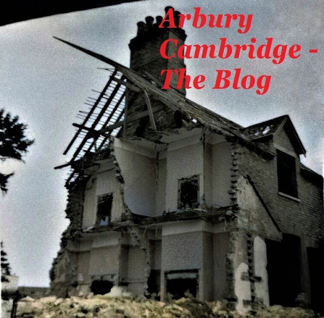
The Council had decided to clear most of the Manor Farm buildings, beginning with the largest house. Vandalism had been something of a problem at the farm in general as South Arbury and East Chesterton had grown - children from further afield were also taking advantage of the farm's potential as a place to 'let off steam' - and particularly in the large old house, which had been empty for some years. It was a popular venue for fun and mischief.
Mike Petty came up with a 1958 Cambridge News report on the subject in recent years:
Mischievous Errand of Five Young Boys
Five lads who appeared before the City Juvenile Court on Monday accused of being concerned together in committing wilful damage to the amount of £2 to windows in Manor Farm House, Arbury Road, were fined 10s each. They were told by the chairman: 'You were probably on some mischievous errand.' One boy denied he did any damage, but had only gone there to play cowboys.
It wasn't only broken windows. Children built bonfires in the overgrown garden and were thrilled to run free inside the house, doing further damage.
My great grandmother, who had been in service at the Manor Farmhouse for Mr and Mrs Pepper in the early 1900s, was living in Brackley Close as work was beginning on North Arbury. She blamed what she perceived as a major fall in standards of youth behaviour on television and the end of National Service!
'Terrible way for a lovely old house like that to end up,' she told me in 1974. 'Shocking behaviour!'
The Manor Farmhouse, circa 1930s, with Colonel Charles Bennett and his son, John. The house was known by locals as the 'manor house'.
The Manor Farm obviously seemed like one huge adventure playground to some of the youngsters on South Arbury and from Chesterton - and many of the smallholders and tenants of the farm were aghast at the change which had suddenly come upon them with the disappearance of Hall Farm.
A massive, brand new housing estate, just the other side of Arbury Road.
Most of the farm cottages were still occupied, and the last person home at night would close the gate across the Drive to Arbury Road, which had always previously been left open. But that was no deterrent to the adventurous young souls from across the way and up the road!
The demolition of the Manor Farmhouse briefly turned the area around the farm Drive into a 'dustbowl' according to Mrs Horne, one of the farm's residents, when interviewed for the Arbury Archive in 1982.
But it was the end of a major attraction for the local youngsters from South Arbury, Chesterton and beyond.
The Manor School would later gain a purpose built Manor Youth Centre but, it seems, the
original (unofficial) Manor Youth Centre was the old Manor farmhouse!
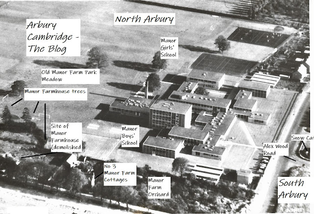
Three trees planted by a former tenant of the farmhouse, Colonel Charles Bennett, were preserved, standing by the boundary fence of the new Manor Schools (separate boys' and girls'), which had opened in 1959.
Only one Manor Farm cottage survived - No 3, which had been built by the County Council in 1924. It still stands today, although much modernised.
The demolition of No's 1 and 2 Manor Farm Cottages. Arbury Court and Alex Wood Road can be seen at the bottom left hand corner of the photograph. Mr Ernest Sale, who lived at No 1, had very much wished to continue living there. When a sewage trench was dug right past his back door for the new estate, he realised the end of his old home was near. He died shortly after leaving the farm in 1961.
Our 1904 Arbury Ordnance Survey map, with the position of the Arbury/Harborough Meadows and Furlongs north of Arbury Road, before the establishment of the Manor Farm in the years following the 1840 Chesterton Enclosures, inserted. Arbury and Harborough were variations on the same name, derived from the prehistoric earthwork. The Harborough version faded from use in the 1800s. We've also marked on the map the Campkin Road and Guided Busway sites. King's Hedges was a fifty eight acre farm north of the Guided Busway. Its name is believed to be derived from a hedged hunting warren in the days of the old Royal Manor of Chesterton. The warren was used for the king's tenants to trap and kill animals - a 'sport' apparently enjoyed by the king from his vantage point in the king's box near the hedges. In the 1800s, local men fought at King's Hedges in organised matches, watched by huge crowds of enthusiastic spectators from both town and gown. The name is sometimes also recorded as 'King's Hedge', singular, into the 19th Century.
1900: The old Manor and Arbury Camp Farms - including the prehistoric Arbury earthwork - and the original King's Hedges, north of the railway tracks/Guided Busway, before its huge road redirection and expansion across the land by Arbury Camp in the late 1970s as part of the A14 motorway development. It then lopped off the original end of Arbury Road! The modern 'King's Hedges', also known as North Arbury, is not actually in King's Hedges at all, but in the old Arbury/Harborough Meadows/Manor Farm fields - the most historic Arbury land in Cambridge city as it saw the first spread of the name beyond the earthwork. The 'real and actual' King's Hedges site now houses the Cambridge Regional College and adjacent buildings, and is straddled by the A14. The Manor Farm field names, from the 1909 sales particulars, and some modern locations for orientation, are featured on our map.
Late 1950s: South Arbury is getting there, though still minus Arbury Court, the Kingsway Flats, etc. North Arbury is still the Manor Farm. King's Hedges is still actually at King's Hedges - north of the railway/guided busway. And Arbury Road still connects the Milton and Cambridge/Ely Roads.
During the first couple of years of the Manor School, cross country runs were very local - simply up the Manor Farm Drive and around the farm tracks. For longer runs, the children would run across Manor Farm, then do a complete circuit of the original, much shorter, King's Hedges Road, Milton Road and Arbury Road.
The shape of the boundary between the old farm buildings and the Park pasture land, including the half circle of the old farmhouse garden, was preserved in the Manor School fence.
Aerial view of the Manor Schools and Campkin Road site in 1960. Note Alex Wood Road was then connected to Arbury Road. Two of the Manor Farmhouse trees labelled are still prominent on the Campkin Road skyline today, opposite the Arbury Town Park and Arbury Community Centre.
Then and now. The Manor Farmhouse garden, and a similar view of the site today.
A front view of No's 1 and 2 Manor Farm Cottages during demolition. The large, modern street lights on Arbury Road give the scene a rather urban feel (compare to the 1955 photograph).
With most of the old farm buildings demolished, work could begin on Campkin Road...
Next time: The Grove School, North Arbury, a sudden flood, and community spirit...
Prints of many of the photographs featured on this blog can be purchased from the Cambridgeshire Collection, Cambridge Central Library - we believe it is an essential resource for anybody contemplating Cambridgeshire history research. There is a wealth of historical material from the county there.


.jpg)


This is great. End of part 1 and the road isn't even built yet! I love all the detail though. But it's taking ages for part 2.
ReplyDeleteSorry, Titch. With Debs being ill we're a bit slow, but we're working on it!
Delete